EB No. 1 – As of November 2, 2019
Pertaining to: Series of Earthquakes with Epicenters in the Municipalities of Tulunan and Makilala, Cotabato Province, Region XII, Mindanao, Philippines
Dates of Incidents: October 16, 29 and 31, 2019 (2 Weeks)
| REGIONAL/PROVINCE/CITY/ MUNICIPAL | No. OF AFFECTED |
| Brgys. | Families | Persons | |
| GRAND TOTAL | 149 | 29,349 | 146,745 |
| REGION XI | 61 | 2,945 | 14,725 |
| Davao del Sur | 56 | 2,924 | 14,620 |
| Bansalan | 17 | 718 | 3,590 |
| City of Digos (Capital) | 3 | 173 | 865 |
| Kiblawan | 1 | 1 | 5 |
| Magsaysay | 21 | 1,951 | 9,755 |
| Matanao | 2 | 51 | 255 |
| Padada | 1 | 2 | 10 |
| Sta. Cruz | 11 | 28 | 140 |
| Davao Occidental | 5 | 21 | 105 |
| Malita | 1 | 1 | 5 |
| Santa Maria | 4 | 20 | 100 |
| REGION XII | 88 | 26,404 | 132,020 |
| North Cotabato | 88 | 26,404 | 132,020 |
| City of Kidapawan (Capital) | 6 | 1,924 | 9,620 |
| Makilala | 38 | 20,704 | 103,520 |
| M’lang | 15 | 117 | 585 |
| Tulunan | 29 | 3,659 | 18,295 |
[1] https://www.rappler.com/newsbreak/iq/243856-things-to-know-about-destructive-earthquakes-mindanao. Accessed November 2, 2019
[1] DSWD DROMIC Report No. 08 on the Ms 6.6 in Tulunan, North Cotabato cited in NDRRMC Update, SitRep No. 08, 02 November 2019, p.
[1] NDRRMC Update, SitRep No. 08, 02 November 2019. Also see Annex B: Assessment of Intensity Felt by Municipality
| I. Description of Incident/s |
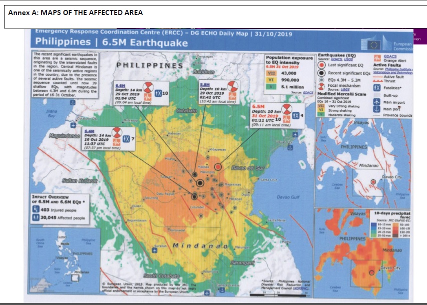
| Four (4) earthquakes of more than Magnitude 6 of tectonic origin struck with epicenters in the municipalities of Tulunan and Makilala, in Cotabato Province, Region XII (SOCKSARGEN) within a period of two weeks. The first earthquake with Magnitude 6.3 struck at 7:37 PM on October 16, 2019 with epicenter at the depth of 8 kilometer in the vicinity of the municipality of Tulunan, Cotabato Province. The second and third earthquake with Magnitude 6.6 and 6.1 struck on October 29, 2019 within 98 minutes apart with epicenters estimated at the depth of 7 kilometers within the municipality of Tulunan. The Magnitude 6.6 struck at 9:04 AM and the following Magnitude 6.1 struck at 10:42 AM. The fourth earthquake with Magnitude 6.5 struck two days after at 9:15 AM on October 31, 2019 with epicenter at the vicinity of the municipality of Makilala, just 33 kilometers away from the town of Tulunan where the first three temblors occurred. The four earthquakes of more than Magnitude 6 and the more than 700 recorded aftershocks of lesser magnitudes, affected an estimated 146,745 individuals in 29,349 families as of November 02, 2019 based on the Situational Report No. 08 of the National Disaster Risk Reduction and Management Council (NDRRMC). The impacts of the four temblors were reported to be felt at Intensity V to VII in 149 barangays in 11 municipalities and 2 cities in 3 provinces in two regions (XI and XII). |
| II. Emergency Context |
| A. Geo-physical Condition As of November 2, 2019, the most affected area is concentrated in a contiguous area that straddles 3 municipalities and one city in Cotabato Province (Tulunan, Makilala, M’lang and Kidapawan City) in Region XII and 4 municipalities and one city (Bansalan, Magsaysay, Matan-ao, Sta. Cruz and Digos City) in the province of Davao del Sur. The affected barangays are situated between 100 to 1,024 meters above sea level (masl) and generally located at the foot and slopes of Mt. Apo, the highest peak in the Philippines, which is among the dormant volcanoes in the country. Except those in the town centers, most of the affected barangays are sloppy to rugged in terrain thus, easily causing landslides. The average elevations of the severely affected municipalities are as follows: Tulunan, 120 masl; Kidapawan, 279 masl, Makilala, 239 masl, Bansalan, 163 masl. Barangay Ilomavis, one of the affected in Kidapawan City, is situated at 1,024 masl. The affected area is among the most seismically active in the island of Mindanao and the Philippines. The active faults that affect Cotabato Province are M’lang fault, Makilala-Malungon fault, north Colombio fault, south Colombio fault and the western extension of the Mindanao fault also known as the Cotabato-Sindangan fault.[7] These fault system seems to crisscross beneath the affected area. PHIVOLCS has reminded the public to be ready for anything, including a much stronger 7.2-magnitude earthquake in that area. “Based on the length of this fault in Cotabato, it’s capable of generating a 7.2-magnitude earthquake, said Dr. Toto Bacolcol, associate scientist at Phivolcs. |
| B. Affected Population As of November 2, 2019, the NDRRMC reported that a total of 29,349 families consisting of 146,745 persons were affected by the series of earthquakes. These affected population came from 149 barangays, of which many are now considered as “no-build zones” due to the landslides and cracks in the surfaces that are indicators that they are situation in major fault zones as explained by the Philippine Institute of Volcanology and Seismology (PHIVOLCS). Table 1: Affected families and Persons by Municipalities[8] Of the total affected families, 4,127 comprising of 20,635 individuals are documented to be taking refuge in the 27 government-designated and recognized evacuation centers. The remainder of the affected families are staying with host families, mostly relatives and friends, and other facilities not officially designated as evacuation centers. The affected population is a mix of Visayans, 75%; Indigenous Peoples (IP), 15% and Bangsamoro, 10% however, in some of the affect barangays of Kidapawan, Makilala and Tulunan, the IP population reached to about 50%. There is no official disaggregation of affected population by ethnicity. In terms of faith, the majority of approximately 85% are Christians belonging to various sects including Catholics, Protestants, Adventists and Evangelicals. A significant number of IP’s are already Christianized while some remain to their indigenous faith. The Bangsamoros are generally Muslims, however, there are also Visayans who converted to Islam. Ethnicity and faith are important factors to consider in responding to emergency in the area especially that there were tensions between Bangsamoro and the Christianized groups in the past. Both the indigenous peoples and Bangsamoro have cultural considerations in terms of food and practices. These needs to be considered by responsers. |
| C. Economic Condition Cotabato province and Davao del Sur are among the provinces in Mindanao with low poverty incidence among families in 2018 at 25.6% and 10.7% respectively. In terms of poverty incidence, the affected municipalities have average income higher than the national average pegged at 16% in 2018 The affected area, located at the food of Mt. Apo has a fertile volcanic soil that are favorable to agriculture. The regions hosts at least eight agro-industrial corporations, most of them have farms in Makilala including rubber and banana producers including DOLE Stanfilco. Palay, corn, coconut, bananas, rubber and various fruits are leading agricultural product of the affected areas. Based on initial estimates in the conditions of affected barangays, majority of the affected families depend their livelihoods on agriculture. Many have farms that provides enough income however many also complained about the high inflation that has eroded their incomes before the series of earthquakes. Since many of the families are scared to go back to their farms, a considerable volume of agricultural products are left unharvested. |
| III. Urgent Needs |
| EcoWEB’s rapid assessment (RA) team deployed in the affected area found that there is an urgent need for temporary shelters, food, water, clothing, hygiene kits and medicines. The team also observed the high degree of traumatization among the survivors due to the quick succession of occurence of the same hazard in just a span of two weeks. The team strongly recommends the provision of the above necessities and the conduct of psychosocial trauma healing activities to all affected population. The provincial and municipal SWD Officers listed the needed assistance in their reports as follows: Family tents for temporary shelters Permanent shelter assistance for families who lost their homes Financial assistance for those families with partially damaged houses Psychosocial intervention, trauma healing for the most affected victims (children, students, women, elderly and persons with disabilities) Tents/makeshift classrooms for damaged schools EcoWEB’s RA Team also noted the request of many survivor families to provide them with assistance in the form of goods, services and cash. Many survivors, especially those affected by the earlier tremblor on October 16, noted that cash assistance could help them recover faster since some of their petty but essential needs could be obtained with cash. Some families expressed that they just need a few kilograms of nails just to repair their houses and few hundreds of pesos to hire labor for the harvesting of their crops. With such small amount they could earn from their farms and get back to their livelihoods faster. |
| IV. EcoWEB Response Plan |
| With the above assessment EcoWEB plans to employ the survivors and communtity-led response (sclr) approach that they used in their emergency response activities to the flooding and earthquake in Caraga Region for the response to the impact of Marawi siege in 2018 in several municipalities of Lanaod del Sur and barangays in Marawi City. Through the sclr approach, EcoWEB shall focus in the least-served areas where the combination of support – goods, services and cash – shall be the main modality of assistance. Goods shall be the modality when the needed goods are not available locally and it is better to procure from nearby towns or cities. Cash shall be given based on the plans of the families and groups. Services shall be in the form of helping families and groups linked with government agencies since most of the affected families are not familiar on accessing post-disaster government services. This will also include skills trainings. |
| V. Suggestion to Other Responders |
| EcoWEB encouraged its local, national and international donors, partner organizations, local civil society groups and kind-hearted individuals to provide a combination of goods and cash assistance to uphold the dignity and encourage creativity among the survivors, two essential ways of helping them recover from trauma. |
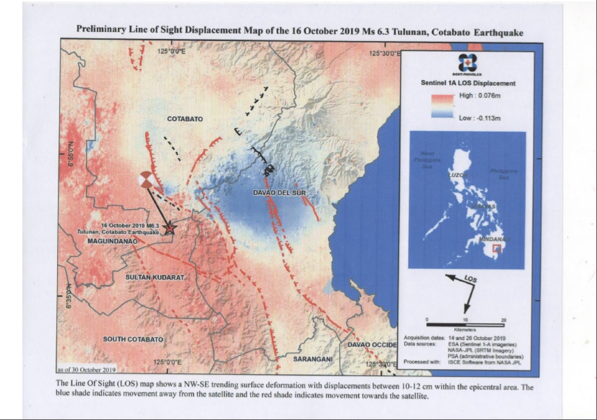
| Annex A: MAPS OF THE AFFECTED AREA |
| ANNEX B: ASSESSMENT OF INTENSITY (AS IT WAS FELT) BY MUNICIPALITY |
| Affected Region, Province and Municipality | Earthquake Incident and Intensities | ||
| Oct. 16, 2019 Mag. 6.3 | Oct. 29, 2019 Mag. 6.6 & 6.1 | Oct. 31, 2019 Mag. 6.5 | |
| Region XII – SOCKSARGEN | |||
| Cotabato Province | |||
| Tulunan | VII | VII | VII |
| Kidapawan City | VII | VII | VII |
| Makilala | VII | VII | VII |
| M’lang | VII | ||
| Roxas | V | ||
| Pikit | V | ||
| Magpet | V | ||
| Pigkawayan | IV | ||
| Carmen | |||
| Antipas | |||
| Matalam | |||
| Kabacan | |||
| South Cotabato | |||
| Koronadal City | V | VI | V |
| General Santos City | V | V | V |
| Sto. Niño | VI | V | |
| Lake Sebu | V | IV | |
| Polomolok | V | V | |
| Tampakan | V | V | V |
| Tupi | V | V | V |
| Surallah | V | V | |
| Banga | V | ||
| Esperanza | IV | ||
| Sultan Kudarat | |||
| Tacurong City | VI | V | IV |
| Kalamansig | V | V | IV |
| Lebak | V | IV | |
| Palimbang | V | ||
| Bagumbayan | V | ||
| Isulan | V | ||
| Sarangani Province | |||
| Alabel | V | V | IV |
| Malungon | V | VII | V |
| Kiamba | IV | IV | IV |
| Maasim | IV | ||
| Maitum | IV | ||
| Glan | IV | ||
| Malapatan | IV | ||
| Region XI – Davao Region | |||
| Davao del Sur | |||
| Digos | VI | VII | |
| Bansalan | VII | VII | |
| Magsaysay | VII | VII | |
| Sta. Cruz | VII | ||
| Matanao | VII | ||
| Hagonoy | VI | ||
| Davao del Norte | |||
| Tagum City | V | ||
| Davao City | V | VI | VI |
| Region X – Northern Mindanao | |||
| Bukidnon | |||
| Quezon | IV | ||
| Kadingilan | IV | ||
| Kalilangan | IV | V | IV |
| Damulog | IV | V | IV |
| Talakag | IV | IV | |
| Manolo Fortich | IV | ||
| Libona | IV | ||
| Misamis Oriental | |||
| Gingoog City | IV | III | |
| Cagayan de Oro | IV | III | |
| Lanao del Norte | |||
| Iligan City | III | IV | III |
| Tubod | IV | III | |
| Bacolod | IV | ||
| BARMM | |||
| Maguindanao | |||
| Sultan Kudarat | IV | ||
| Matanog | IV | ||
| Barira | IV | ||
| Cotabato City | IV | V |
[1] NDRRMC Update, SitRep No. 08, 02 November 2019. Also see Annex B: Assessment of Intensity Felt by Municipality
[2] NDRRMC Update, SitRep No. 08, 02 November 2019.
[3] Same as above NDRRMC Update.
[4] NDRRMC Update, SitRep No. 08 – 11 in Cotabato Province, 3 in Davao del Sur, 2 in South Cotabato and 1 in Sultan Kudarat
[5] NDRRMC Update, SitRep No. 08 – 253 from Cotabato Province, 40 from South Cotabato, 11 from Davao del Sur and the rest from adjacent provinces.
[6] NDRRMC Update, SitRep No. 08, 02 November 2019.
[7] https://www.rappler.com/newsbreak/iq/243856-things-to-know-about-destructive-earthquakes-mindanao. Accessed November 2, 2019
[8] DSWD DROMIC Report No. 08 on the Ms 6.6 in Tulunan, North Cotabato cited in NDRRMC Update, SitRep No. 08, 02 November 2019, p.